->

28 January 2011

Paris Open Data Released

Paris Open Data Released
Paris OpenData in many different data types.

The data held by the City of Paris are fully exploited by the municipal services as part of their missions, but are also an intangible heritage that can be developed for the whole community:
  • researchers can find material to feed their work and experiences,
  • developers can create innovative services using these data,
  • citizens and journalists to find raw information,
  • companies can provide added value to these data, and thus create jobs and wealth for the community.

The movement "Open Data" (open data) is to get any type of structure, including local authorities around the world, the provision of all, free and free of electronic data. More Data to come in the weeks.

Now map it.
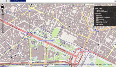
Paris Open Data Released in Open Street Map
Already in OpenStreetMap - http://demo.3liz.fr/opendataparis

Labels: , , ,

02 June 2010

Map Open Data with Google Fusion Tables

Map Open Data with Google Fusion Tables

With all the Open Data coming online is it easy to take for granted what can be done with it.
But the fact is a file that holds location-al information is great but even better with a map.

Example
Warkwickshire Bridges Map Fusion data
Presentation of the Bridge Height data from Warwickshire County Council in a visual map shows a much more valuable way to deliver the information. proving that the information behind the markers is more important.

source data:
http://opendata.warwickshire.gov.uk/datasets/bridge-height-restrictions

(xls file saved as a csv and uploaded to fusion tables)

Note: Easting and Northings [UK Grid Reference]- quick conversion to latitude and longitude with a slight offset.
Offsetting the marker makes it easier for the user to identify the location of the bridge in this case.

Warkwickshire Bridges Map Fusion Table data

load into google fusion tables
http://tables.googlelabs.com/DataSource?snapid=57803

map
http://tables.googlelabs.com/DataSource?snapid=57802

Then the final Map is just wrapped
in an iframe an offset has been included with bridge locations
done so not to obscure marker data and table information

Final map Zoom in and select Satellite MapType to see the offset markers next to the bridge
http://mapperz.110mb.com/GMAP/warkwickshire_bridges.html

Important Note to Local Authorities
would be good if all the county/metropolitan councils could get this data ready like this!

Labels: , , , , , , ,
