OpenSpace API - More Examples Please
OpenSpace API - More Examples Please
15/02/2008
Keep them coming... (and keep asking the OS for 1:25,000 Explorer Mapping!)

http://www.geothings.net/openspace/index.html
blog post
openspace-licences-limits-and-first-steps-plus-demo
OpenSpace API - More Examples Please
A few weeks on from the Ordnance Survey releasing the OpenSpace API there are a few that are taking up the small challenge and using the API to full effect.

Very Clever
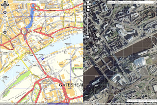
http://wheresthepath.googlepages.com/wheresthepath.htm
Note: Spilt screen half OS OpenSpace API and half Google Maps API Aerial imagery and is linked by location (pan and zooom can be enabled)
Blue transparent box shows the extent - switches between the maps.
Another Great Example

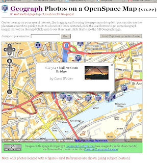
Geograph Photos on a OpenSpace Map (v0.2c)
http://openspace.nearby.org.uk/geograph.php
(Please do not use the page to plot locations for Geograph!)
Suggestions to make a better Mapping API - OS 1:25k would complete the set as there is a big jump between 1:50k mapping and 1:10k Streetview mapping.
Note: 1:25k is available on the Get a map service. Then you would be able to plan walking and hiking trips using the OpenSpace API. (1:25k has all public footpaths)
Not asking for 1:10k Rasters or MasterMap but there needs a scale.
There needs to be more Official Examples and better documentation with clear examples.
http://openspace.ordnancesurvey.co.uk/openspace/support.html
maybe and Advanced Section showing users the full potential of what can be done.
Working pages rather than static images with code would also be a helpful guide to newcomers to mapping API's.
Know of another OpenSpace API Map or have another suggestion? Then add yours via the comments.
Note:
"Newcastle-upon-Tyne" needs to be "Newcastle upon Tyne" or you will get an error.
Note:
"There will be a outage today 14th Feburary OpenSpace has a planned downtime from 5-6PM GMT today."
Labels: API, Exmaples, Maps, OpenSpace, Suggestions


