->

04 September 2008

InLET Earthquake Simulator Map

InLET Earthquake Simulator
(Internet-based Loss Estimation Tool)
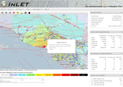
INLET Earthquake Simulator
Customize your own scenario with this Earthquake damage predictor.

The results display potential damage to property (none, slight, moderate, complete)
Also predicts the number of casualties that could arise.
Number of bridges effected.

Other functions are available
Ground Shaking: Peak Ground Acceleration
Real-time (the past 7 days of activity)

Lots of other functions, layer controls, layer transparency, facilities.

Based on Microsoft Virtual Earth mapping

Try this mapping tool out here:
http://rescue-ibm.calit2.uci.edu:8888/inlet/inlet.php

source:
http://www.liveside.net

Labels: , , , , ,

27 February 2008

UK Earthquake Map

Update 28/02/2008
From the comments
http://virtualtourism.blogspot.com/2008/02/uk-earthquake.html

UK Earthquake Map


View Larger Map


"The
British Geological Survey recorded an earthquake with a magnitude of
5.2 ML 4 km north of Market Rasen, Lincolnshire, at 00:56 GMT. The BGS has
been inundated with calls from the public, media and emergency services
throughout England. By 7 am this morning, over 1,400 felt reports had been
received via the online questionnaire on the BGS website.
There is a report of one person having been injured.
Reports indicate that the earthquake has been felt widely across England, with reports
of damage to chimneys in the epicentral area. Earthquakes of this size occur in
the mainland UK roughly every 30 years, although are more common in
offshore areas. This is the largest earthquake in the UK since the magnitude
5.4 ML Lleyn Peninsula."

Source:
http://www.telegraph.co.uk/news/main.jhtml?xml=/news
/2008/02/27/nquake527.xml

data source:
http://pasadena.wr.usgs.gov/shake/ous/STORE/
X2008nyae/ciim_download.html

Labels: , , , , ,