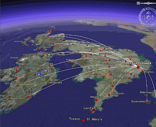
UK and Ireland Flight Maps (Google Earth)
UK and Ireland Flight Maps (Google Earth)

Created by http://www.barnabu.co.uk/
KML file available:
http://www.barnabu.co.uk/uk-and-ireland-flight-maps/
"The Placemark balloons include information about airlines and destinations.
Labels follow Wikipedia’s convention of using place names rather than real airport names.
Routes are displayed with exaggerated altitude. "
Guidelines:
"One downside of Google Earth’s highlight mode is it doesn’t stay switched on a after a mouse click. However, there are a few navigation tricks that allow you to keep routes displayed and move around."
- Click the middle mouse button on an airport icon, and hold it down while moving the the mouse.
- Hover the mouse pointer over an icon, then switch to keyboard control (cursor keys, shift + cursor keys, Page up/down, + key, - key, etc…).
- Click on an airport icon, quickly drag it and let go. Just as you would to set the Earth rotating.
Data source:
"The source data for all this is scraped from the Airport pages on Wikipedia, and compiled using a lot of Perl scripting to scrape, mash and meld it into KML. Obviously its never going to be 100% reliable, but at least it should be pretty easy to keep the file regularly updated, and expand to other parts of the world."
Nice use of Wikipages and Google Earth.
Mapperz
Labels: Animated, Banabu, Flights, Google Earth, Ireland, KML, UK


0 Comments:
Post a Comment
<< Home