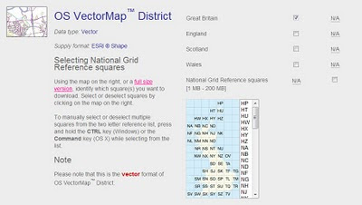
Ordnance Survey Maps Vector Map District Available
Ordnance Survey Maps Vector Map District Available

Finally a very useful dataset from ordnance survey for users wanting to create cartographic maps at mid-scale. Licence favourable for the use (with source attrbution) for the like of open street maps and others.
Techie spec.
| Specification | OS VectorMap District | |
| Coverage | Great Britain ( England, Scotland and Wales ) | |
| Data source | Majority of content derived from the mid-scales database. Buildings, cartographic text and functional sites derived from large-scale database. | |
| Data structure | ESRI® Shape | |
| Scale | Nominal scale is 1:25 000. Recommended scale range is 1:15 000 to 1:35 000. | |
| Storage (unzipped) | Tiles range between 6 - 20 Mb | |
| Vector styling | Shape format is supplied without styling, enabling users to customise the data to suit their needs. | |
| Product content | Each vector feature has its own feature code, and falls within one of 15 layers: A full list of feature codes and layers can be found here. | |
| Number of tiles | 2860 tiles cover Great Britain | |
| Tile size | 10km x 10km | |
| Coordinate reference system | OSGB36. (@mapperz will have a WGS84 version by May2010) | |
Data Available to Download Here:
https://www.ordnancesurvey.co.uk/opendatadownload/products.html
Labels: District, Map, Ordnance Survey, OS OpenData, Vector


3 Comments:
the obvious thing that's missing is public footpath and other public access info that's on Explorer/Landranger maps
this looks like something very interesting and I'll let my fellow members at http;//landsurveyorsunited.com know about it..thanks for the tip!
There are lots of royalty-free vector maps of Britain and Ireland on www.maproom.net. Good if you need to use a map base for commercial work, which OS doesn't allow for its free maps.
Post a Comment
<< Home