TopOSM Updates
TopOSM Updates
The 'prettiest' form of Open Street Map has a nice clean update:

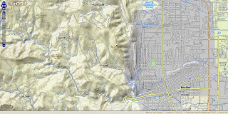
TopOSM has new coverage - Colorado
Permalink - http://toposm.com/co/?zoom=14&lat=40.0303&lon=-105.30387&layers=B0TT
(Links to the map above)
TopOSM Changes:
- Released TopOSM Colorado
- Colour-by-elevation in base layer
- Contour lines and hillshading generated from the USGS National Elevation Dataset (NED)
- Hydrography (lakes, rivers & wetlands) from USGS National Hydrography Dataset (NHD)
- The hillshading, contour lines and map features are on separate layers. Use the layer switcher (top right "+") to toggle.
"I created a Python script to generate map legend HTML snippets - complete with images - from mapnik description files and a short description file that specify what features to include. You can see the result at http://toposm.com/ma clicking on the "Show/Hide Legend" at the bottom right. Legends are specific to the current zoom level, so they will refresh when zooming in and out."
"I also added elevation labels for contour lines. The only issue is that the data from MassGIS (where the contours come from) is in meters (3 meter interval) and my map is entirely in ft, so the values look a bit funky sometimes. Not much I can do about that, though..."
Lars Ahlzen
Lots of minor other improvements too. There's a full change log at:
http://toposm.com/changelog.html
As always, the map is at http://toposm.com/
Full Credit to Lars Ahlzen in this excellent version of Open Street Map
he notes:
"It took longer than I thought, but I've finally released TopOSM (my OSM-based topographic map project) for the state of Colorado."
Source:
http://www.openstreetmap.org/user/Ahlzen/diary
Previous Posts:
http://mapperz.blogspot.com/2009/04/toposm-pretty-openstreet-map.html
Labels: Lars Ahlzen, Open Street Map, OSM, Pretty, TopOSM, Updates, USGS


0 Comments:
Post a Comment
<< Home