Virtual Earth (6.2) Reverse Geocoder
Virtual Earth (6.2) Reverse Geocoder
"Geocoding is the process of finding associated geographic coordinates (often expressed as latitude and longitude) from other geographic data, such as street addresses, or zip codes. With geographic coordinates the features can be mapped and entered into Geographic Information Systems, or the coordinates can be embedded into media such as digital photographs via geotagging."
"Reverse Geocoding is the opposite: finding an associated textual location such as a street address, from geographic coordinates."
http://en.wikipedia.org/wiki/Geocoding
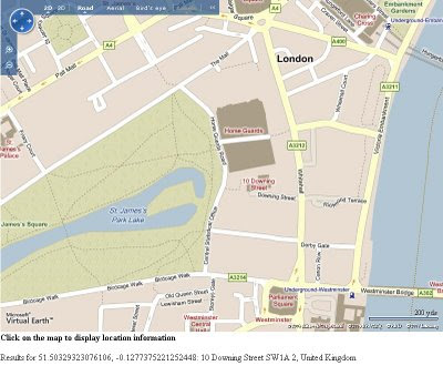
Clicking on the map near roads sends a request to get the address by location (street number, street name,postcode/zipcode & country). In the screenshot a click was made halfway along 'Downing Street' response was 10 Downing Street, SW1A 2, UK.
Virtual Earth has been updated and there is lots of advances and new features this is just one working example that can be implemented in a few lines of code.
To see this working as it should:
http://mapperz.googlepages.com/Virtual_Earth_62_Reverse_Geocoder.html
It will work for any location in the World that is covered by Roads on the Virtual Earth Platform
For more official information please vist
Labels: 6.2, Addresses, Geocoder, Geocoding, New, Reverse, Virtual Earth


0 Comments:
Post a Comment
<< Home