UK Tidal, Wave, Wind Power Maps
UK Tidal, Wave, Wind Maps
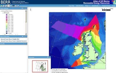
See the power visually with these colourful maps.
"A project commissioned by BERR in 2007 has taken the existing UK Marine Renewable Energy Resources Atlas forward. This new stage of development for the Atlas has enabled an enhanced definition of the primary resource variables and is now a product that is being made more accessible though a webGIS interface. The charts in the Atlas indicate the distribution of potential resource for the future deployment of renewable energy technologies – wind, wave and tidal. The project team was led by ABP Marine Environmental Research and included the providers of major marine data holdings (Met Office and Proudman Oceanographic Laboratory (POL))."
http://www.renewables-atlas.info/index.asp

Wave Power - useful for surfers..

Tidal Power

Wind Power
ArcServer is used to process the geospatial data (cells) and export the results into Excel Format.
GIS Data is downloadable in ESRI Shapefile or MapInfo .tab formats
http://www.renewables-atlas.info/downloads.asp
Map Help
http://www.renewables-atlas.info/Help/Default.htm
Labels: Arcserver, Energy, Maps, Renewable, Tidal, Wave, Wind


2 Comments:
wow that's sounds interesting...
Beach Resort
Wind power is not a solution. The whole truth about wind turbines is never told by lobbyists and governments.
How could the very weak and extremely unreliable initial energy source of a wind turbine ever produce a steady power of any significance?
Please think!
And read: “Wind energy- the whole truth” at: http://www.windenergy-the-truth.com/
Post a Comment
<< Home