The Times: Best walks in the British Isles with Maps
The Times: Best walks in the British Isles with Maps
The Times are promoting the best of British walks with the use of custom made route maps and Google maps.
The Routes are also available for Mobile Phones:
http://timesmobile.mobi/walks
Here are the 20 Walks in PDF Format
All have Blister Ratings, Pub Ratings and View Ratings.
1. Alfriston - Seven Sisters, East Sussex, by Alan Franks
2. Oxford - Wolvercote circular by Libby Purves
3. Branscombe to Beer, Devon, by Monty Halls
4. Land's End to Nanjizal by Alex Wade
5. Withypool, Exmoor, Somerset by Alice Thomson
6. Porlock Weir to Culbone Church, Exmoor, Somerset by Joe Swift (Porlock Weir spelling is wrong on the pdf)
7. Oxwich Bay, Gower Peninsula, Wales by Kate Humble
8. Brecon Beacons Horseshoe, Wales, by Damian Whitworth
9. Snowdon via the Pyg Track, Wales by David Aaronovitch
10. Malham Cove , Yorkshire Dales by Matthew Hoggard
11. Muker-Keld, Yorkshire Dales by Ann Treneman
12. Seathwaite - Scafell Pike, Lake District by Giles Whittell
13. Ullswater, Lake District by Hunter Davies
14. Arthur's Seat, Edinburgh by Hugo Rifkind
15. Skipness-Claonaig, the Kintyre Way, Scotland by Ben Macintyre
16. Sileve Binnian, Mourne Mountains, Northern Ireland by David Sharrock
17. Chew Green, Northumberland by Christopher Somerville
18. Blythburgh - Eastbridge, Suffolk by Simon Barnes
19. Wells-next-the-Sea to Cley, Norfolk by Richard Morrison
20. The New River and the Lee, Hertfordshire by Derwent May
**There seems to be a copyright acknowledgment issue here - some pdf's reveal that there is Ordnance Survey 1:50,000 rasters underneath the 'walking route maps' but there is no crown copyright acknowledgment on the map or pdf's. Hope the Times realize this is breaking crown copyright.

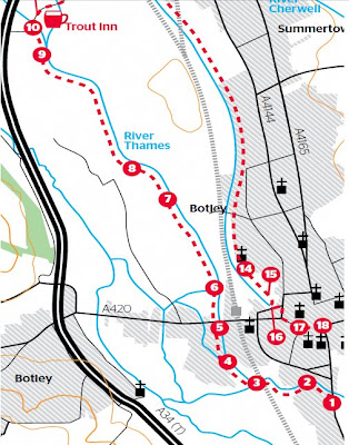
Two Botleys on the - map confusion - No Oxford? - Summertown sliced off and where are the toilets? No Scale? No copyright**? [image for illustration only]
Cartographically these maps are not the best - the editors missed the importance of Toilets on the routes and there are various spelling mistakes and label mis-placement but they do guide you for their purpose.
They do also presume you have the relevant Ordnance Survey Explorer Maps [1:25,000].
These can be viewed from Multimap [OS Map mode] and Where is the Path for free.
Labels: 20 Walks, Crown Copyright?, Directions, Maps, PDF, Routes, The Times


1 Comments:
Best walks in the UK, but not a single route in the Highlands, what a strange idea!
Post a Comment
<< Home