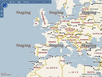
Virtual Earth 6.2 Maps [Sneak Peek]
Virtual Earth 6.2 Maps [Sneak Peek]

French Language Map Tiles soon to be available

German Language Map Tiles soon as well

Italian Maps
You can see what is new in Virtual Earth 6.2 [but not fully updated yet]
http://dev.live.com/virtualearth/sdk/
* Static maps
* Direct map tile access
* Aerial map imagery metadata
* Pushpin clustering
* Landmark-based directions
* Improved geocoding
* Expanded rooftop geocoding in the US
# Pushpin clustering. Use the VEShapeLayer.SetClusteringConfiguration Method to set how to display and cluster overlapping pushpins for better shape display at higher altitudes.
# Hints for route instructions. Help your users find route turns with hints about nearby landmarks and intersections using the VERouteItineraryItem.Hints Property.
# Imagery metadata. Retrieve information about imagery using the VEMap.GetImageryMetadata Method.
# Base map disabling. Use the Virtual Earth Mercator projection in non-mapping applications by turning off the base map with the VEMapOptions.LoadBaseTiles Property. You can use the VEMap.HideScalebar Method as well.
# Support for other languages. Retrieve maps with labels in French, German, Italian, and Spanish from Virtual Earth. See the Returning Localized Results topic for a list of supported culture strings.
# 3D model import. Import 3D model data files into a shape layer using the VEMap.Import3DModel Method. Interact with these models as you would any shape.
# Updated interactive SDK. See the new functionality of the Virtual Earth map control demonstrated in the updated Virtual Earth Interactive SDK.
[not yet available]
Mapperz Source:
http://www.nateirwin.net/post/Virtual-Earth-62-Coming-September-22nd.aspx
[but it's the 24th September]
Labels: 6.2, French, German, Italian, New Maps, Sneak Peek, Spanish, Virtual Earth


0 Comments:
Post a Comment
<< Home