UK Incinerator Map Launched
UK Incinerator Map

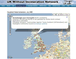
UK Without Incineration Network (UKWIN) has launched a Interactive Map that show existing and potential new sites for Household Waste Incinerators - Grey markers represent existing incinerators. Brown markers represent potential incinerators.
UKWIN, in collaboration with Friends of the Earth, has developed an interactive map of existing and potential household waste incineration sites.
"The map, which was unveiled today (July 22), documents 23 existing sites and outlines 150 locations that have been scouted for around 80 more facilities to be built and includes a table listing every facility with its location, type, capacity, operational notes and active campaign groups opposing that particular site.
Large urban areas are identified as the areas with most incineration facilities - Birmingham, London, Liverpool and Leeds all accumulating high numbers - while smaller areas such as Invergordon, Inverness, and Jersey's proposed St. Helier facility expose the range of the research undertaken.
UK WIN explains that it placed each location on the map based on facility post codes for accuracy."
Source:LetsRecycle.com
Related: Channel 4 News - 30 new rubbish incinerator plants planned for the UK
Labels: Existing, Household, Incinerator, Map, Potential, UK, Waste


1 Comments:
Excellent Map. Very accurate and a excellent layer of publically salient information with clickable information links. Well done UKWIN/FoE, and the groups involved. A real focus of information.
Post a Comment
<< Home