My Maps Service - New from Google Maps
All New from Google Maps 'My Maps' - Make your own Custom Maps with help from Google Maps
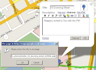
Like this....

(note mapperz not really having Tea with the PM purely for example reasons and testing this useful service out)
So how do you get this to work?
Easy if you have a Google account. If you want one you can sign up here
Login and go to http://maps.google.co.uk
or your localized area eg http://maps.google.com
Click on My Maps New
In the Left Table of Contents
You will notice some new icons appear
Pan, Create Marker, Create Line, Create Polygon
Now Search for your area of interest, 10 Downing Street, London, UK in this instance
this will zoom into and place a 'found' marker to show you the centre point.
Now you can add your own marker (like mapperz has to locate Number 10)
This is easy to create and edit, you can have as many markers as you like.
Google provide a tool tips help when using the point, line and polygon in edit mode.

Want to edit the colour and transparency of the polygon?
easy

Transparency or Fill Opacity can be changed so that the background mapping can be seen.
Default is 45, (100= solid fill, 0= no fill)
Okay now you have a go!
Top Tip: If you want a KML file so you can view in Google Earth you can use the KML Icon in the Top where 'Link to Page' is located.
To add an image - use the 'Rich Text' Mode

Click on the image icon on the toolbar and find a copyright free image or your own which is hosted on a webserver/site.Copy Image Location on the image and paste into the prompt on the My Map Editor as above.
The same can be done with Video from the likes of You Tube, MySpace etc.
For a more interactive tutorial (video) please visit the following (after the ad)
http://news.com.com/1606-2_3-6173473.html?tag=ne.vid
Want more information on this?
Google Earth Blog does a good round-up of this new service...
"The really interesting aspect to the announcement is that the underlying data is all KML! KML is the file format for Google Earth content - and now Maps too. This means you can create your maps and then click on the "KML" in the upper right of the map and immediately view the content in Google Earth. Furthermore, when you search for content you will not only be able to get local business search results, but also get KML search results (just like the recent KML search update for Google Earth). Look for a "See user-created content" link after the other results - it only appears when there is relevant content searched in the current view (see example)."
Source: Google Earth Blog
more info to feed on here...
Official Post: map-making-so-easy-caveman-could-do-it
Official 'My Maps' Help: http://maps.google.com/help/maps/userguide/index.html
And of course Google Maps Mania blogged it.
mapperz
Labels: Custom Map, Google Maps, Mapperz, My Maps, New Service


0 Comments:
Post a Comment
<< Home