Your Map Data to KML
Update 09/08/2007
WHAT'S NEW IN VERSION 2.3:
- graduated marker symbols are now supported
- multi-part features are now supported
- the feature name can now be explicitly defined
- bunch of other bug fixes, minor tweaks and improvements
INSTALLATION:
Refer to "Export_to_KML_Documention.pdf" for information on installing
and uninstalling the extension.
NOTE:
This is a free, open source product. While I'll continue to make improvements,
if you need much more sophistication than this tool offers,
check out the commercial software.
RECENT FIXES (Version 2.3):
6/12/07 - updated documentation; added uninstall script
5/10/07 - fixed issue with circles and curves not being exported from geodatabases
3/27/07 - removed unnecessary leading commas from KML coordinates; makes output
KMLs compatible with Google Maps API
Your Map Data to KML for use in Google Earth or Google Maps
(and gain more visitors to your site/blog)

World cities in Google Earth from a Shapefile

KML to Google Maps
So you have vast amounts of data offline?
You want more Visitors to your website.
Here is an unofficial and not supported post to boost your audience using geographical data.
Have tested this and works. mapperz
Ingredients
- 1 Webserver (or free service like Google Pages)
- Some data (say shapefiles of UK Towns)
- A little bit of code (honest it's only little bit)
- some links

your right it a bit boring! and what has this got to do with KML?
OK for this to work you need your GIS data in WGS84 format.
In your GIS (in this case ArcMap) Project the data using project in the toolbox
Note:If you data does not have a .prj file with shapefiles use define projection before the project command.
This will make the data into Geographic projection (yes you will be able to overlay it in google map and google earth in a minute)
Now do a Calculate (ArcGIS 9.2 users have it easy by using the Calculate Geometry option)

pre 9.2 you need to create two fields x&y or lat&lng
if doing this a lot easier if you use the free code from Ianko Tchoukanski
So now you have the geographical values.
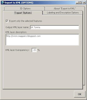
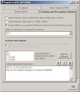
Using ArcGIS and a free script
Export to KML 2.3.4
http://arcscripts.esri.com/details.asp?dbid=14273
"Export to KML is an extension developed for ArcGIS 9.x by the City of Portland, Bureau of Planning. The extension allows ArcGIS users to export GIS data in “keyhole markup language” (KML) format for viewing in the free Google Earth data viewer. Any point, polyline, or polygon dataset, in any defined projection, can be exported. Features can be exported as either 2-dimensional features, or 3D features "extruded" upwards by an attribute or z-value. Some other features: ability to incorporate ArcMap layer symbology into the exported KML; labeling of point, line, and polygon features; "describe" individual features using the database attributes."
Please note: you will be making this data available to the whole world and make sure you own copyright to the data.
Why all this effort?
Make Kml available helps your potential users find you/your website/blog as google seem to be ranking geographical data higher than other web formats (plain old html, xml).
Making your kml available online is also available through the google earth application and with 200 million downloads, it is going to help pull people towards your website.
Remember content is King.
Working Examples
Google KML File Directory (for Example purposes)
http://mapperz.kml.googlepages.com/home
View in Google Earth of the Option of viewing in Google Maps
sitemap (key to indexing kml files)
http://mapperz.kml.googlepages.com/sitemap.xml
Sources:
http://googlemapsapi.blogspot.com/2007/01/get-more
-traffic-to-your-maps-api-site.html
http://www.sitemaps.org/protocol.html
http://www.google.com/apis/maps/sitemap.html
MIME types to the server and Network Links
- application/vnd.google-earth.kml+xml kml
- application/vnd.google-earth.kmz kmz
posting-kml-on-web-server.html
Labels: Googke Earth, Google Map, KML, Traffic, Visitors, Your Data


0 Comments:
Post a Comment
<< Home