Google Earth vs ArcGIS Explorer
Google Earth vs ArcGIS Explorer which is better?

Well this was one of the quickest tests mapperz has ever done.
Google Earth Wins! by a mile.
The simplest of tasks - search for '10 Downing Street, London, UK'
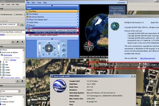
Google Earth - 3 seconds to rotate the earth and zoom right into Downing Street and display the aerial photographs at full resolution.
ArcGIS Explorer - Place not Found, Please check your spelling....
(login needed)
ESRI can we please have ArcGIS service pack 1 before the end of the year?
(ESRI software users know about the x.0 curse)
Mapperz recommends Google Earth for the time-being.
Update:

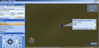
Okay so now you can find 10 Downing Street, London, UK
After entering 3 Input Boxes and Scrolling through a long list to Find Great Britain and Northern Ireland.
Then it did not actually find it after asking for conformation.
But look at the image it's not clear and does not show the real location.
Took 34 seconds to do this in ArcGIS Explorer and this result is not really what the 'User' wants.
Google Earth still wins... in our book.
The other very annoying feature is you cannot add personal geodatabases to ArcExplorer.
Time to convert .mdb into .kml??
Labels: ArcGIS Explorer, compared, Earth, ESRI, Google


5 Comments:
Excellent test!
Also came in at 3 seconds for Virtual Earth, and 5 seconds at Yahoo! Maps with the error "The street could not be found, but here is the center of the city".
How is ESRI going to compete with MS and Google, one wonders...? They should stick to high end tools and leave the delivery to those more experienced with scaled solutions.
Use find address, not find place.
White House: place
1600 Pennsylvania Ave: address
10 Downing Street, London, UK: address.
Works fine for me if you pick the 'Find Address' task in the task bar.
'10 Downing Street, London, UK' or even just 'Downing Street' now work just fine in ArcGIS Explorer ...
excellent test? You've got to be kidding.. So you pull one address out of who knows where and time it and thats your test? What a joke.. ArcGIS explorer works fine, and no I'm not an ESRI guy. Maybe the problem is with the user...Sure you could make the argument that ArcGIS Explorer isn't as intuitive, but without a more in depth study that would be subjective too, right? As far as the comment about ESRI sticking to high end tools and leaving the delivery to those more experienced...ArcGIS Explorer was never meant to compete with MS or Google products. Where are the geoprocessing capabilities in Google Earth?? Google Earth is a pretty picture, that's it. In my opinion, Google Earth is an excellent program for what it was designed to do - visualize. But you guys are comparing apples to oranges, and by the looks of the "test," you had already decided that you like apples better. So as long as we are making assumptions and not a fair, unbiased assessment, I will go ahead and make the assumption that you guys are probably web geeks and probably have very limited experience with geoprocessing and geospatial technologies...
Post a Comment
<< Home