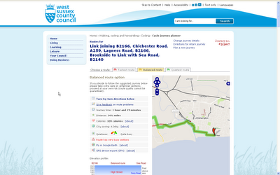
Local Government - Open Cycle Journey Planner
Local Government using CycleStreets based on OpenStreetMap OpenCycleMaps
Users can add their own - http://wiki.openstreetmap.org/wiki/Cycle_routes

An Excellent addition to West Sussex County Council - Find your quietest journey to work, school or even for leisure.
Features:
- Turn-by-turn directions
- Journey time:
- Distance:
- Calories:
- CO2 saving:
- Quietness-o-meter
- Route has very busy sections
- Fly in Google Earth
- GPS device export (GPX)
- Elevation Profile.
Try your own journey by bicycle:
http://cyclejourneyplanner.westsussex.gov.uk/
Labels: Cycle Map, CycleStreets, Journey, Planner, West Sussex County Council


1 Comments:
Hi Mapperz,
BlogFront.org is committed to uphold the quality standards of blogging. We strive to maintain and promote only the most credible blogs in their respective fields.
Spam blogs or "splogs" has been a problem for some time now and people are getting confused about which blog to trust.
We would like to thank you for maintaining such a reputable blog. We know that it takes time, effort and commitment to keep such a blog and as such, we have added your blog as one of the top Geography Blogs.
You can see your blog listed here: http://blogfront.org/geography/2
You can also claim your BlogFront Top Blogs badge at http://blogfront.org/badges/geography
Thank you for keeping your blog credible. Let's keep the blog revolution alive!
Maria Blanchard
BlogFront.org
Blog Revolucion
Post a Comment
<< Home