Cartographic Representations in Google Maps and Virtual Earth
Cartographic Representations in Google Maps and Virtual Earth

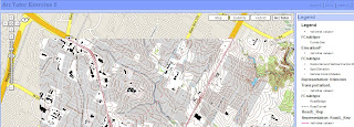
Cartographic Representations are part of ArcGIS 9.2 that improve the cartographic elements of GIS data, making it aesthetically more pleasing.
However Brain Flood spatialdatalogic.com has been working on some clever techniques to
make this end result available through Google Maps and Virtual Earth
"Topo Map - this is an export of one of the Cartographic Representation tutorials. It's a good example of complex, scale dependent map symbology"

This is driven by Amazon Web Services Amazon Simple Storage Service
"Amazon S3 provides a simple web services interface that can be used to store and retrieve any amount of data, at any time, from anywhere on the web."
Combining these services is producing some very powerful applications on which one could dream up a few years ago.
Nice work more please - Mapperz
Labels: Amazon S3, ArcGIS 9.2, Cartographic, Google Maps, Representations, Virtual Earth


0 Comments:
Post a Comment
<< Home