Microsoft MapCruncher
From Microsoft Research
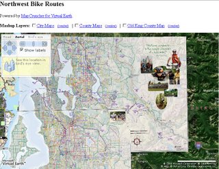

MapCruncher makes it easy to publish maps overlaid on Virtual Earth. Once you are familar with the tool, it will take you about ten minutes to crunch a new map. Just find 5 to 10 corresponding landmarks on your map and on Virtual Earth, and MapCruncher will register your map to the global coordinate system, warp it to fit a Mercator projection, and generate a set of image tiles that can be seamlessly mashed up with VE's standard road or aerial imagery. It even makes a sample HTML page to show you how to use your mashed-up map.
MapCruncher accepts a variety of vector formats (PDF, WMF, EMF) and raster formats (JPG, PNG, TIFF, GIF, BMP).
"The Virtual Earth API allows web developers to supplement Virtual Earth's maps with pushpins and lines. MapCruncher brings mashups to a whole new level by allowing developers to import entire maps to supplement the existing road and aerial imagery with detailed, application-specific information. The possibilities are endless: bicycle maps, transit maps, national park maps, university maps, antique city maps, or whatever drawn-to-scale maps you personally find interesting. You can even augment Virtual Earth with Do-It-Yourself Aerial Photography."
posted by Mapperz @ 5:47 pm
1 comments
![]()
![]()


1 Comments:
Useful information ..I am very happy to read this article..thanks for giving us this useful information.Fantastic walk-through. I appreciate this post.
Antique print
Post a Comment
<< Home