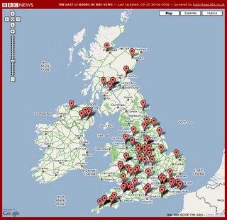
BBC News UK Map - Powered by BBC BackStage

News Maps for the United Kingdom. Powered by BBC Backstage, reports the last 12 hours of news.
Clean and easy to use.
credit to Ben O'Neill
Mapperz - The Map & GIS News finding blog. With so many Mapping sites online. This blog tries to provide you with the best maps and services that are currently available online. @mapperz

3 Comments:
That's very nice but the markers don't point to the story. A classic example is an article about the MotoGP at Donington Park points to Donington Village 55 miles away, an article about a Road closed in Birmingham points to Rode in Somerset, 110 miles away. These types of maps work if the data is accurate and more importantly usable. In this case searching for "placenames" and automatically pointing to what comes first doesn't work.
I Agree, the feeds seem to be finding the first place name and geotagging that location.
The better way would be to use postcodes as the BBC do here
http://www.bbc.co.uk/england/
but postcodes are property of Ordnance Survey codepoint
http://www.ordnancesurvey.co.uk/oswebsite/products/codepoint/
and that does not come cheap (unfortunately).
Nice ideas, keep them coming.
Maybe BBC can supplu GeoRSS feeds in the future.
http://georss.org/
Mapperz
The BBC's RSS feeds don't contain any geo information other than place names, the script attempts to work out where the news items are coming from (it tries to pick the most likely using a simple algorithm) but it's not always correct!
Post a Comment
<< Home