Free Ordnance Survey Maps for the iPhone
Free Ordnance Survey Maps for the iPhone
iOSMaps v1.0 has launched.
"Get the OpenSpace Ordnance Survey© mapping application for the iPod Touch© and iPhone© from the iTunes© Store for FREE right now!"
"The application is intended to be free, making use of newish technologies to showcase the awesome possibilities/fun of marrying different technologies. I see iOSMaps being used in replacement of paper Ordnance Survey maps. For what every your outdoor pursuit, be it mountaineering, skiing, fell running, hiking, cycling or a good old fashioned walk, just enjoy using the application on your iPhone"
Author of this application
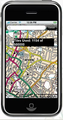
What is looks like on screen? (minus the tile number)

This service is not the fastest, but does work well, though you will find high data transfers costs using this service. But the idea is right, if caching of data is allowed on the phone in theory the user can 'cache os maps' before they venture out with the device.
iOSMap uses the new the mapping data provided by the OpenSpace API from Ordnance Survey, to show feature rich geographic, geotopic and cartalogic data of Great Britain. The application make use of OpenLayers, gmaps and prototype libraries and was written using the mighty iPhone sdk in Objective-C 2.0 and C.
Geeky info:
client:
iPhone/iPod Touch.
OpenLayers:Map,Control,GridProjection
OpenSpace 0.72:Map, Gazetter, GridProjection
Prototype1.6:prototype.js, scriptalicios.js
Google:gMapsAjaxSearch, googlemaps (check terms of use using google maps api and openspace api together?)
But very promising and will be the future of mapping, though not sure it will replace paper/book maps as they never run out of batteries...
Mapperz
To get the free OS Maps App on the iPhone website is:
http://www.publicfootpaths.com/
Labels: 50k, Footpaths, Free, iPhone, iTouch, Maps, OS, Walking
0 Comments:
Post a Comment
<< Home