http://www.theukmap.co.uk/
http://www.theukmap.co.uk/
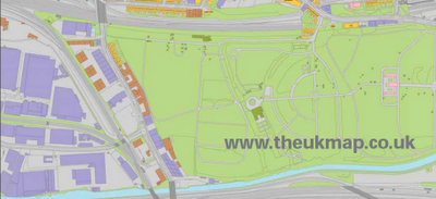
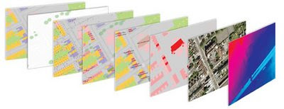
01/06/2009 - Press Release The GeoInformation Group Announces UKMap Programme New large-scale mapping for the UK "Cambridge, 1 June 2009: The GeoInformation® Group today announces a ground breaking and innovative new mapping programme. UKMap® is the UK’s first commercially funded, large-scale topographic mapping and address database created completely independently of the Ordnance Survey®. "UKMap is a modern, highly detailed, feature rich mapping database. It comprises of several map layers designed to be used as a single integrated geographic information database. UKMap layers include a 1:1,000 scale topographic map layer accurately locating all buildings, extensions, garages, property boundaries, roads, road markings, rivers, trees and many other features of our environment. Other layers include a location database holding addresses, commercial and retail names, building heights, tree heights, street names, government offices, and place names. In addition to these layers there is an aerial photography layer and a digital terrain model."

Is the data derived from the Ordnance Survey?
NO!
"No absolutely not. All the buildings, roads and all line work was digitised from our own aerial photography, and all the information collected in the field by our survey team was done so by writing down on our digitised maps everything they could see. The only piece of third party data that is within the UKMap database, and it is optional, is the Postcode"
Detailed Method for the digital mapping layers:
"Well first we use our latest high resolution aerial photography, all captured using a very advanced digital camera at 12.5cm resolution. The aerial photos are orthorectified using GPS and a very detail terrain model from our own Cities Revealed LiDAR database. This gives us a very accurate stereo aerial photo database from which we can digitise; the accuracies of our air photo database and the subsequent features we digitise have been tested and show absolute positional accuracies compared to independent GPS points of 0.7m RMSE (Root Mean Squared Error). We then digitise, using stereo pairs, all features we can see in the photo, such as fences, buildings, road markings, trees bridges etc. These are all digitised with some key tools so we ensure parallel lines, right angled corners and splines for curves. This all makes for a much neater, accurate and cartographically improved line map. The digitised maps are then printed and sent out to our field survey team who then walk every street, park, office complex in fact anywhere where there is public access to collect all the information we need and add that to our map, this includes house numbers, street names, shop names, locality information, office names etc. All this data is then complied into the UKMap database. "
UKMap is made up of the Topo product suite, comprising of 8 map layers, and the Thematic product suite, a 1:5,000 scale map layer with annotations for use on the web.
This is very good.

Why use it?
Cost
- Cost Savings
UKMap contains a number of data layers that you would normally pay extra for:- Addresses
- Points of interest including retail and commercial data
- BLPUs
- Aerial photography
- Terrain
- Land Use
- 3D buildings
Labels: http://www.theukmap.co.uk/, Independant, Large Scale Mapping, Non-Ordnance Survey, UK
1 Comments:
Thanks for the pick up. We are going crazy here right now with all the interest. I'll try to post more on our blog to keep you all up to date (released today)
http://theukmap.blogspot.com/
Alun
Post a Comment
<< Home