UK Bluetongue Map
UK Bluetongue Map showing Control Zones in the UK

Blue Range Rings 20km
Red Polygon Simplified Control Zone
Black Polygon Simplified Protection Zone
Cause?
"Transportation of the virus by midges is believed to have occurred on a Southeasterly wind from the continent.
Thetford has been selected as a centre point of East Anglia and the centre point of the range rings that are spaced 20km apart.
As the map shows spread of the virus is greatly affected by climatic conditions such as wind and temperature.
As wind direction is a significant factor in the spread of the virus, winds from the Northeast and Southeast quadrants pose the greatest risk of the virus spreading, along with a mild winter.
DEFRA control zones could very well change on a daily basis so farmers are well advised to check with DEFRA on the latest situation.
Please check the map (gets updated).
http://www.gis-logic.co.uk/bluetongue.htm
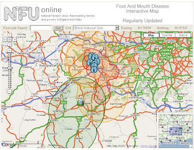
Also available is nice interactive version for Foot & Mouth
http://www.gis-logic.co.uk/footandmouth.htm

Red Circle/Polygon: Foot and Mouth Protection Zone
Orange Circle/Polygon: Foot and Mouth Surveillance Zone 10KM
Dark Green Circle/Polygon: Lifted Zones
No Mapperz does not have Bluetongue or Foot and Mouth. But this map is a better solution than defra pdf and slightly interactive maps.
Please refer to Defra for up to date information.
Labels: Bluetongue, Control Zones, Defra, Foot and Mouth, Map, Protection Zones
3 Comments:
Like the BNG coordinates in the toolbar. Any idea how I could replicate that anyone?
jakc
try the javascript file
http://www.gis-logic.co.uk/scripts/gm_bluetongue.js
but credit the gis-logic team.
Mapperz
Mapperz
On screenshot I can see map on nfuonline.com
Can you share link to the page with this map, please?
Post a Comment
<< Home